Frequently asked questions:
#1:
Q: Can I download the data from EGDI?
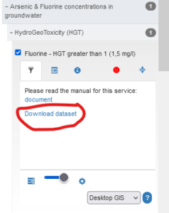
A: Some data can be downloaded. That applies to data uploaded as GeoPackages or Shape files. In some cases you can also download a pdf-, tiff. or similar files with the same content as the map shows. If the provider of the data has allowed it such files can be downloaded from the left menu:

#2:
Q: Do I need an account to get access to data?
A: No. The only thing you need an account for is if you want to upload your own data to be part of the EGDI system.
#3:
Q: How can I get my own data on the EGDI map?
A: Data from relevant geoscientific projects are very welcome on EGDI. We will, however, need to have a dialogue with you before they are uploaded in order to maintain a consistent platform. Please have a look at the page “How to get involved”.
#4:
Q: How can I search for datasets?
A: There are several ways to locate the desired information. On the one hand, you can access the information through the Scientific Theme to which they belong to. If you are looking for datasets you can use Data Search. If you are interested in searching for documents (PDFs, images and CSV files) access the Document Repository. If you are interested in metadata following the INSPIRE Directive and the ISO 19115 standard you can access the Metadata Catalogue.
#5:
Q: What is the difference between EGDI and EPOS.
A: It can be confusing that there presumably are two infrastructures for geological data in Europe, EGDI and EPOS. But they actually have very different functionality, contain different kinds of data, and are serving different user groups.
EGDI contains primarily geological data in a broad sense (basic geology, mineral resources, geoenergy, groundwater, geochemistry, geohazards, urban geology, etc.). In many cases these are harmonised, pan-European datasets. EGDI also contains reports and other documents from geological projects.
EPOS gives access to research infrastructures for solid earth sciences, for instance seismological, near fault, and vulcanological observatories, GNSS and satellite data as well as geomagnetic observations and multiscale laboratories. A limited number of data layers from EGDI are also accessible on EPOS, including a surface geological map, index information about boreholes, mines, and index information about 3D geological models.
#6:
Q: I want to get in touch. how do I do that?
A: If you have a question not answered here, want to upload data, or want to get in touch for whatever reason? See the Contact Page for information.
#7:
Q: Will more data be available in the future?
A: EGDI is continuously publishing new data. Many datasets were included recently during the GeoERA and many more datasets will be included soon during the GSEU, which started in the autumn of 2022.
#8:
Q: Where can I find a list of all services that are publicly available?
A: You can refer to the List of layers and their status. You can also find services through the Data Search and the Metadata Catalogue.

