Abstract:
The transnational EU Interreg North-West Europe project DGE-ROLLOUT aims to promote the Deep Geothermal Energy (DGE) potential of the North Upper Rhine Graben and of the Lower Carboniferous carbonate rocks (Dinantian). The latter occur widespread in the North-West European subsurface and are expected to be a favorable reservoir for hydrothermal energy extraction.
Besides the Geological Survey of North Rhine-Westphalia as the lead partner, the DGE-ROLLOUT project partners include the national geological surveys of Belgium, France and the Netherlands, as well as industry partners (DMT GmbH &Co. KG; Energie Beheer Nederland B.V; RWE Power AG) and research institutions (Fraunhofer Institution for Energy Infrastructures and Geothermal Systems; Technical University of Darmstadt; Flemish Institute for Technological Research).
In this application, an overall view through an interactive online map was developed merging the baseline sources to identify potential geothermal hotspot regions within the project area. The basis for this categorization comprises harmonized geological knowledge, DGE resource potential and the market/investor correlation (socio-economic potential).
Project facts:
Project duration: October 2018 – October 2023.
Project Lead: Ms Anna Thiel, Geological Survey of North Rhine-Westphalia (GD NRW) DGE-ROLLOUT@gd.nrw.de.
Website: https://www.nweurope.eu/dge-rollout.
Decision-making tool
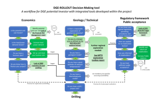
The decision-making tool reveals step by step which questions (in blue boxes) a potential DGE investor is recommended to answer before the drilling of a deep geothermal well, following three main axes: Economics, Geology/Technical, and Regulatory framework/Public acceptance. A positive answer leads to the next question. If the answer is “no”, actions are suggested (green boxes) or tools and helpful reports are provided, which have been developed within the DGE-ROLLOUT project (light green boxes).

DGE-ROLLOUT webtool
The DGE-ROLLOUT web application combines surface data (e.g. heat demand, socio-economic potential) and subsurface data (boreholes, seismic lines, harmonized top and thickness maps, heat in place) to assess the geothermal potential. The application illustrates the expectedly most promising areas (called hotspots) to launch investigations on building up a DGE project in the Dinantian reservoir in Belgium, northern France, the Netherlands, the state of North Rhine-Westphalia in Germany (2D maps) or in some parts of the northern Upper-Rhine Graben in Germany (3D Viewer available).
The uncertainty maps are key elements to understand the level of confidence of the various layers available in this tool.
Disclaimer
The User acknowledges and accepts that the data and maps displayed are the result of analytical and numerical models and algorithms based on available data, current scientific knowledge, statistical analysis and intrinsic simplifications. They mainly aim at providing initial information on the situation of the studied areas. In situ analysis by experts in geological and structural behavior is required to analyze and validate these initial data. Therefore, the partners of the DGE-ROLLOUT consortium cannot under any circumstances, be it individually or collectively, guarantee or be held responsible for the accuracy, merchantability or applicability of the data for any particular purpose. The User acknowledges that the data and maps are provided without warranty of any kind.
The displayed information should be interpreted by persons with competence and an appropriate level of skills in the specific areas such as, for example, engineers, architects, geologists, etc. The partners of the DGE-ROLLOUT consortium cannot be held liable in any way, individually or collectively, for any interpretation of the information such as, by way of example but not limited to, structural, geological interpretations derived in any form or by any means from the data and maps. Nor can they be held liable for any loss or damage incurred by the User or any third party deriving, directly or indirectly, from (i) further processing of the data and maps; or (ii) any interpretation and/or use of it by the User or third parties.

